Hartshorne Woods Park is a prime hiking destination as it features spectacular views of the stately woodlands, streaming rivers, and sublime ocean, all wrapped up in one. While the park caters to novice and seasoned hikers alike, it is renowned for its strenuous trails in a magnificent setting.
The Hartshorne Woods Park hiking trails in New Jersey were formerly a WW2-era defense post. The park is comprised of the Buttermilk Valley, Monmouth Hills, and Rocky Point areas which feature several well-maintained trails and side trails with incredible views of the forests, river, and the ocean.
Although the park has several well-demarcated and maintained trails, the less well-known side trails are hidden gems that simply must be explored. So, read this article to find the park’s best-kept secrets!
Hartshorne Woods Park: What You Should Know
The 736-acre Hartshorne Woods Park is situated in Northern Monmouth County, New Jersey, one of the most elevated regions in the spectacular Bayshore Region.
The park, steeped in history, was previously a coastal WW2-era defense artillery location and is still home to several Battery Lewis “bomb-proof” bunkers dotted along the trails.
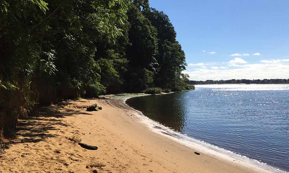
It offers scenic views of the Shrewsbury and the Navesink rivers, including the Sea Bright beach shoreline. It has subsequently become a major attraction for outdoor enthusiasts who enjoy hiking the strenuous 16-mile trail system.
Hartshorne Woods Park comprises the following three hiking areas: Buttermilk Valley and Monmouth Hills, including the Rocky Point hiking areas, which feature group cabins, fishing areas, cross country, hiking, and horse-riding trails.
The well-marked park trails have various designations ranging from green (for easy) and blue (for intermediate) to black (for seasoned hikers), and they are all spot on!
The rocky black marked trails are strenuous; the blue marked trails demand a level of technical skills to navigate. In contrast, the green-marked trails are great for novice hikers or seasoned hikers who want to increase their hiking speed.
However, ensure that you have a map on hand as the park can sometimes be challenging to navigate, especially the tricky black diamond trails that could send you in the wrong direction.
While the park is open from 07:00 AM to 09:00 PM, it can be closed during hunting seasons, so look at the Monmouth County Parks website before you strap on your hiking boots.
The Rocky Ridge: Intermediate Hiking Trail
The Rocky Ridge 2.3-meter-long unpaved trail meanders along the scenic Rocky Point ridge above the Navesink, and Shrewsbury rivers, including the Sea Bright Atlantic Ocean, with several lookout points to catch your breath while enjoying the bounty of nature.
Although the paved Rocky Point trailhead is situated in the northeastern section of the parking lot, take the unpaved route that heads into the woods, which concludes at a trail intersection between the Grand Tour and the Command Loop trails.
The unpaved road shoots off in a westerly direction while the paved trail heads off in an easterly direction back to the parking lot.
However, you can also explore the Black Fish Cove side trail, which leads to the Navesink river pier with idyllic views of the Hartshorne Woods and the beautiful surrounding landscape.
Buttermilk Valley Entrance Laurel Ridge: Intermediate Trail
The spectacular Laurel Ridge, a 2.5-meter loop trail, meanders through the scenic, hilly woodland with American holly trees and mountain laurel.
The Laurel Ridge starts in the Buttermilk Valley section of the park and takes approximately an hour and 13 minutes to complete at a brisk pace.
If you should battle to find parking during peak hiking seasons, simply head to the adjacent Huber Woods parking lot.
There are three trailheads at the Buttermilk Valley; take the path with a Blue Square demarcation and not the Green Circle trails.
However, if you mistakenly enter the park at the Rocky Point entrance, simply take the gravelly 1-mile Cuesta Ridge trail toward the Buttermilk Valley entrance, Laurel Ridge trailhead, a quick 10-minute walk at a modest pace.
While there are numerous partially secluded areas on the trail that joins up with the Grand Tour and Cuesta trails in parts, keep an eye out for mountain bikers that frequent this beautiful trail.
Alternatively, extend your day by taking the Buttermilk Valley trail towards the Rocky Point trail viewing area with sublime vistas of the peaceful Navesink River.
The Grand Tour: Intermediate Hiking Trail
Unlike some of the other trails, the 3.4 miles long Grand Tour pathway does not go toward the rivers or past the WW2-era bunkers; it heads straight through the heart of the park with a few hilly sections in between, which is moderately strenuous and takes about 2 hours to complete.
The Grand Tour meanders through stately poplar trees, including underbrush carpeted with otherworldly Porcelain Berry vines that are sadly an invasive species.
Although this trail is incredibly popular with avid hikers, dog walkers, mountain bikers, and fishermen, it is still possible to experience blissful solitude.
While the Grand Tour trailhead is situated at Cuesta Ridge, it is far easier to use the paved hiking trail that starts at the parking area and leads to an intersection with the Command Loop, Rocky Point Trail, including a non-descript gravel path.
This trail overlaps with the Laurel Ridge Trail in a western direction, which can be followed as an extended loop trail.
Rocky Point & The Grand Loop: Intermediate Hiking Trail
The 4.3 miles long, moderately challenging Rocky Point and Grand Loop Trail provides magnificent views of the beautiful woodland, river, and pristine shoreline takes approximately 2 hours to complete.
Like the previously mentioned trails, it is incredibly popular or crowded at times. However, there are still areas where you peacefully commune with nature.
Before you strap on your hiking boots, grab a sturdy pair of hiking poles as this trail has shifting rocks dotted along the way, and they will be extremely helpful in safely navigating the terrain.
The Battery Lewis: Easy Hiking Trail
While the short but sweet Battery Lewis trail is less than a mile long, it is an excellent hike for military enthusiasts, showcasing old WW2 gun batteries used to protect the New York harbor.
The Battery Lewis trail ambles towards the back of the bunkers; then, it loops to their façades, where you will find a 120 ton, 68-foot-long naval gun.
While the park’s map notes that the Battery Lewis trail goes through a bunker, the gate is mainly closed. So, follow the unpaved trail towards the parking area, or make a day of it and explore other trails in this magnificent park.
Conclusion
The Hartshorne Woods Park, with its peaceful woodlands, rivers, and breathtaking ocean views, is truly a hiker’s haven with well-maintained trails that are just waiting to be explored. So pack up that backpack, and have a great time!