Arizona is undoubtedly a stunning place to visit. Yes, there are major towns to visit, including Flagstaff and Phoenix, but the state’s natural splendor makes it so unique. Therefore, there is plenty to see around the state, from national parks to unspoiled valleys. That said, what are some of the best hiking trails in Arizona?
On foot, Arizona’s diverse landscape makes it one of the most beautiful states in the country. Your travels may take you through Saguaros in the desert or Devils Bridge in Sedona. Furthermore, there is no shortage of awe-inspiring sights in the Grand Canyon and the Chiricahua Mountains.
Arizona’s hiking trails provide a diverse range of magnificent sights and experiences, ranging from easy to difficult, encompassing a diverse range of terrain, topography, and climate conditions. With that in mind, let’s look at some of the best spots that Arizona has to offer.
The Best Hiking Trails Found In Arizona
The Tonto Rim, Palm Canyon’s unique groves of native trees, ancient lava flows, stunning Slickrock, the vivid turquoise of Havasu Falls, and more are all part of Arizona’s crown treasure.
Trails for all levels of hikers are laced throughout the multipart landscape. There’s something for everyone, from ADA-accessible loops with incredible vistas to genuinely grueling treks that put even the experienced outdoor athletes to the test, from petroglyph-strewn desert slopes to urban jaunts you can accomplish with a to-go coffee in hand.
If you’re probing for ways to make the most of your stay in Arizona, look no further than the most excellent places to visit in the state, starting with the Devils Bridge Trail.
Devils Bridge In Coconino National Forest
Devils Bridge is the most prominent natural sandstone arch in the Coconino National Forest’s Sedona region. It is a fantastic climb with stunning views of Red Rock country.
Don’t be fooled by its name: it’s one of the most beautiful sites in an area known for them. During this moderately challenging, 1.8-mile roundtrip hike, the elevation gain is just 400 feet from the trailhead elevation of 4,600 feet.
The climb to the summit won’t leave you gasping for air, but we can’t say the same for the vistas you’ll see once you’ve arrived. Although this route is short, it does have a steep climb near the finish. The official trailhead is located along the unpaved Dry Creek Road (FR 152) and needs a high clearance vehicle to reach.
If you only have a low-clearance vehicle, park in the Dry Creek Road trailhead parking lot, about a mile from the official trailhead, or the Mescal Trailhead on Long Canyon Road.
To meet this route, park at the Mescal Trailhead and travel the Mescal Trail to Chuckwagon Trail. Follow the Devil’s Bridge Trail sign from the parking area. Because the path was initially built as a jeep trail, it is smooth and passes through washes of juniper and prickly pear cactus.
You’ll proceed up a natural rock stairway with breathtaking views until you reach the Bridge’s base. Then, you’ll come to another set of steps that will lead you to the Bridge. This famous path is a popular tourist destination, so get there early to escape the throng.
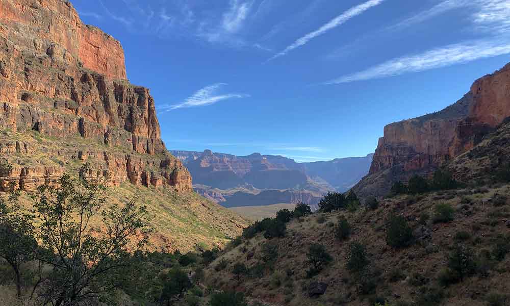
The Bright Angel Trail In The Grand Canyon
It’s no surprise that one of Arizona’s most famous climbs takes place in one of America’s most spectacular natural wonders.
The Bright Angel Trail descends into the Grand Canyon from the Grand Canyon’s South Rim. You can trek all the way down to the Colorado River, although this usually takes more than one day. Several spots along the path provide suitable day-hiking opportunities, ranging from a half-mile trek to a difficult 12-mile hike.
The route is steep and follows the canyon wall, with massive drop-offs on both sides. Anyone afraid of heights should think twice before embarking on this trek. Bright Angel is only one of the many hikes available in the Grand Canyon. If you don’t have much time or don’t want to expend as much energy, you can choose the simpler pathways.
Seasonal circumstances range from ice and snow in the winter to sweltering heat in the summer—the best periods to visit the Grand Canyon area in the spring and fall for hikers.
Bull Pastures And Estes Canyon Loop Trail
This often-overlooked park in Arizona’s deep south, near the Mexican border, has spectacular views and a fantastic hiking track. However, the major attraction for tourists to this location is the possibility to witness organ pipe cactuses, which are only found in Arizona’s far southern borders.
The Bull Pasture and Estes Canyon Loop Trail leads you up into the mountains, through some breathtaking scenery, with views of the canyon, desert, the steep rock walls of the mountains you’re climbing, and views of the mountains in Mexico.
The route and the mountainside are lined with saguaros and organ pipe cactuses, and wildlife abounds. The Bull Pasture Trail leads to the right from the parking lot, while the Estes Canyon Trail leads to the left, and the two paths finally intersect on a high ridge.
You’ll notice a spur that rises another half-mile through rugged terrain where they meet. Although this side spur is only.5 miles long, it is relatively steep. The path is three miles round trip with 1,000 feet of elevation gain and may be done as an in-and-out trek to Bull Pasture.
Chiricahua National Monument, Echo Canyon Trail
The ash from a volcanic explosion eroded into balanced rocks and hoodoos, forming the Chiricahua Mountains. It is the essence of the Southwest! Canyons and stone constructions entirely distinct for Arizona may be seen in this area of rock pinnacles and otherworldly hoodoos high above the desert.
The best hike or at least the most popular hike in this area is known as Echo Canyon or “Big Loop,” as it loops you around the Chiricahua National Monument park. After traveling the park’s 8-mile picturesque route, you’ll arrive at the Echo Canyon Trailhead.
Cathedral Rock Trail, Coconino National Forest
Cathedral Rock in Sedona is a short but difficult trek that gives spectacular views of the red rock country’s naturally occurring rock formations. It is a popular trip for hikers of all ages due to its beautiful landscape and short distance. If you ever find yourself trekking in Sedona, be sure to add this one to your list!
You’ll have to struggle up a variety of rocks to get to the summit. These rocks have been frequently trafficked and are pretty slick. As well as wearing the right shoes, it would help if you packed your belongings so that your hands are free and you can scramble and maintain three points of contact.
Off of Back’O’Beyond Road, you may reach the Cathedral Rock Trailhead. Two parking lots are available. The Baldwin and Templeton routes, however, provide access to the path.
In the southern portion of Sedona, the trek to the summit of Cathedral Rock is a must-do. Although the journey is just around 1.5 miles round trip, the elevation rise of 740 feet makes it a moderately demanding hike with sections that require near-vertical ascent.
Follow the basket cairns to remain on track as you struggle your way up the rough terrain. The trek might take anything from half an hour to an hour each way from the trailhead.
The views from the top of the trek are well worth the effort, especially around sunset. To make the trek up and down simpler, use excellent closed-toed hiking shoes with sufficient traction.
Summit Trail #300 At Piestewa Peak
Hikers, walkers, sightseers, and runners alike are drawn to Piestewa Peak like moths to a camping lantern, owing to its closeness to the Phoenix metropolitan area. Yet, despite the crowds, this mountain can be a lot of fun, with a short but strenuous climb and several spectacular views of the Sonoran desert along the route.
The parking area is located off Piestewa Peak Drive and connects several hiking trails to the Phoenix Mountains Preserve. The hike begins with a short connection track before heading straight up to the peak. This summit trek is ideal for those searching for a challenging exercise.
Camelback Mountain, the Dreamy Draw Recreation Area, and the city of Phoenix are all visible from the summit. The Piestewa Peak Summit Trail is particularly suitable for a sunset trek.
Navajo Nations Antelope Canyon
Antelope Canyon, which has been often photographed, is another short yet magnificent trek in Arizona. This slot canyon is a photographer’s ideal destination, with tiny curving walls that enable shafts of light to pass through from above.
You’ll need to take a tour to get here, but it’s a really straightforward process. It’s only a short ride out to the slot canyon’s mouth, where you may explore around the canyon at your leisure, with a guide to keep you safe.
It’s only a half-mile walk into the slot canyon and back, and the land is level. Antelope Canyon is in Northern Arizona, near the town of Page. If you’re staying in Flagstaff, you may take an organized tour of Antelope Canyon and climb to Horseshoe Bend, which is another fascinating part of the nation.
Antelope Canyon, in the American Southwest, is a well-known slot canyon. It is built on property held by the Navajo Nation, specifically by the Bengay Family, who have been long-time Navajo residents. This area is located in northern Arizona, east of the city of Page.
Trail #108 West Fork Of Oak Creek
This seven-mile Sedona trip is semi-shaded by trees and surrounded by high canyon walls, making it ideal for beating the heat.
One of the finest hiking experiences in Sedona is trekking up Oak Creek’s west branch, which is already recognized as a hiker’s paradise. The trees’ sheer canyon walls and shelter make this an ideal path for avoiding the Arizona sun.
Enjoy the magnificent vistas of the canyon walls towering above you as you follow the creek upstream through beautiful sandy pathways and thirteen various stream crossings. The crossings are relatively straightforward unless the waters are high, and the height increase on this path is minor.
The route comes to an end when the canyon walls shut in on you, and there’s nowhere more to go without becoming soaked. Feast your eyes upon the fantastic vistas, take advantage of the picture-perfect scenes, and wonder at how the river has carved away at the rock over millennia.
You may continue wading upstream for another quarter mile or so if you’re properly outfitted. The pebbly stream bed can be a little rough on bare feet, but it might be comfortable for you; nevertheless, be wary of the smoother rock surfaces beneath the foot, which are very slippery.
Trailhead parking is limited at the Call of the Canyon day-use area, 11 miles north of Sedona, which may be an issue for some, but early birds will enjoy a reasonably uncrowded path.
Flatiron Via Siphon Draw Trail
The Flatiron via Siphon Draw Trail is a difficult day trek in the Superstition Mountains. It is full of challenging scrambles and is only suitable for experienced hikers and scramblers, so wear durable shoes and bring lots of water!
Several rock slides have occurred in recent years, and the top section of the route has been significantly affected. Therefore, please use caution and heed warnings. To help you navigate, look for the blue and white markers.
You will travel up Siphon Draw Trail from the Siphon Draw trailhead, leaving from the parking area. You’ll swiftly cross the Jacob Crosscut Trail intersection before continuing on to Slick Rock and then Siphon Falls.
After that, you’ll reach the saddle before completing the final difficult ascent to the top. The views from the summit are unquestionably worth the effort, and it’s a fantastic spot to take a rest before walking back down.
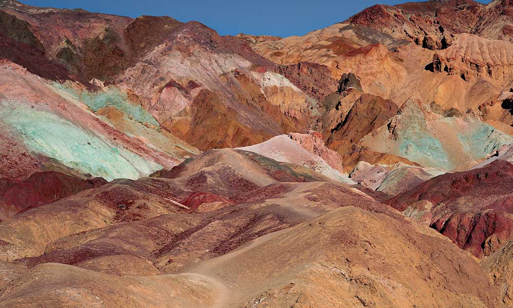
The Wave In Paroa Canyon
If you’ve ever visited an Arizona photo gallery, you’ve undoubtedly seen photographs of The Wave, a whirling orange sandstone landscape that resembles a stone wave. The Coyote Buttes Special Management Area is located in Paria Canyon, which has this natural feature.
While The Wave is the most famous trek in the area, several other excellent hikes are nearby. A special permit for Coyote Buttes North is required to trek to The Wave, a moderate 5.5-mile day trip. Unfortunately, it can be difficult to get due to the lottery method and the limited number of tourists allowed into the region each day.
A permission can be obtained four months in advance, although no motorized vehicles, including drones, are permitted in the area.
Conclusion
No matter how much hiking experience you have, you will be able to choose the perfect path for you! Remember to pack adequate water and food with you, regardless of whatever trail you choose to hike.
Some routes have places where you can replenish your water bottle, and some even have rangers patrolling them, but solely depending on that would be unwise, so always stock up! Staying hydrated is essential, especially in the heated summer months.